
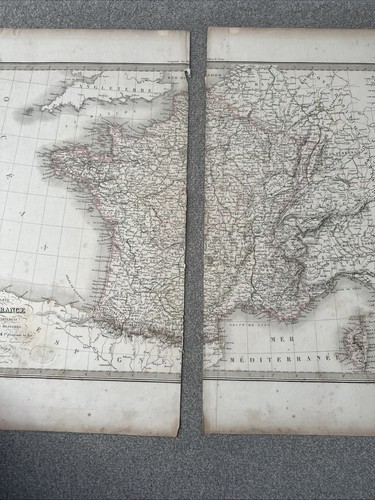
Lapie Antique Map of France 1842 Carte comparée de la France en 1789 et 1813
GBP 74.97GBP 74.97
Wed, Aug 06, 01:06 AMWed, Aug 06, 01:06 AM
Picture 1 of 18


Gallery
Picture 1 of 18
Have one to sell?
Lapie Antique Map of France 1842 Carte comparée de la France en 1789 et 1813

GBP 74.97
ApproximatelyC $140.70
or Best Offer
Condition:
Oops! Looks like we're having trouble connecting to our server.
Refresh your browser window to try again.
Shipping:
Located in: Thirsk, United Kingdom
Delivery:
Varies
Returns:
No returns accepted.
Payments:
Shop with confidence
Seller assumes all responsibility for this listing.
eBay item number:116698518059
Item specifics
- County
- France
- City
- Paris
- Type
- Topographical Map
- Cartographer/Publisher
- Pierre M. Lapie and Alexandre E. Lapie.
- Date Range
- 1842
- Format
- Sheet Map
- Original/Reproduction
- Antique Original
- State
- Dordogne
- Printing Technique
- Copper Plate
- Year
- 1842
- Country/Region
- France
- Era
- 1800s
- Antique
- Yes
Item description from the seller

Seller Feedback
No feedback yet
More to explore:
- Paris France Antique Maps,
- France Antique Europe Topographical Maps,
- France Antique Europe Railroad Maps,
- France Antique Europe River Maps,
- France Antique Europe Novelty Maps,
- France Antique Europe School Maps,
- France City Map Antique Europe Atlas Maps,
- France Antique Original Antique Europe Novelty Maps,
- Antique European Maps & Atlases Lyon France,
- Paris France Antique Europe Railroad Maps
Seller Feedback
No feedback yet