
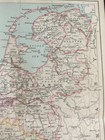
Antique Map Netherlands & Belgium Dated 1887 Europe Colour Map Of The World Art
GBP 13.99GBP 13.99
Tue, Aug 19, 02:17 AMTue, Aug 19, 02:17 AM
Picture 1 of 5


Gallery
Picture 1 of 5


Have one to sell?
Antique Map Netherlands & Belgium Dated 1887 Europe Colour Map Of The World Art
GBP 13.99
ApproximatelyC $25.94
Condition:
Oops! Looks like we're having trouble connecting to our server.
Refresh your browser window to try again.
Shipping:
GBP 4.95 (approx C $9.18) Standard Int'l Postage.
International shipment of items may be subject to customs processing and additional charges.
Located in: Great Torrington, Devon, United Kingdom
Delivery:
Estimated between Mon, Sep 8 and Mon, Sep 22 to 94104
Ships today if you order in the next 59 mins
Returns:
No returns accepted.
Payments:
Shop with confidence
Seller assumes all responsibility for this listing.
eBay item number:135823550673
Item specifics
- Antique
- Yes
- Printing Technique
- Lithography
- Cartographer/Publisher
- J BATHOLOMEW
- City
- Brussels
- County
- N/A
- Date Range
- 1800-1899
- Type
- World Atlas
- Format
- Folding Map
- Year
- 1887
- Era
- 1800s
- State
- various
- Original/Reproduction
- Antique Original
- Country/Region
- Europe
Item description from the seller
Seller Feedback
No feedback yet
More to explore:
- Belgium City Map Antique Europe Atlas Maps,
- Belgium County Map Antique Europe Atlas Maps,
- Netherlands Antique Europe Sheet Maps,
- Belgium Antique Europe County Maps,
- Belgium Antique Europe Sheet Maps,
- Belgium Antique Europe Folding Maps,
- Netherlands City Map Antique Europe Sheet Maps,
- Netherlands Antique Europe City Maps,
- Belgium 1910-1919 Date Range Antique Europe Sheet Maps,
- Brussels Belgium Antique Europe City Maps