Picture 1 of 5


Gallery
Picture 1 of 5


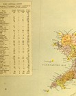
1883 LETTS MAP NORTH WEST ENGLAND & WALES MONTGOMERY CAERNARVON ANGLESEY
GBP 28.00
ApproximatelyC $51.94
or Best Offer
Condition:
“See listing”
- Buy It Now1883 LETTS MAP NORTH WEST ENGLAND & WALES MONTGOMERY CAERNARVON ANGLESEY
Oops! Looks like we're having trouble connecting to our server.
Refresh your browser window to try again.
Shipping:
GBP 15.00 (approx C $27.82) Royal Mail International Tracked.
International shipment of items may be subject to customs processing and additional charges.
Located in: York, United Kingdom
Delivery:
Estimated between Mon, May 5 and Tue, May 13 to 43230
Please allow additional time if international delivery is subject to customs processing.
Returns:
14 days return. Buyer pays for return shipping. If you use an eBay shipping label, it will be deducted from your refund amount.
Payments:
Shop with confidence
Seller assumes all responsibility for this listing.
eBay item number:143348546532
Item specifics
- Seller Notes
- “See listing”
Item description from the seller

Seller feedback (20,072)
- b***l (37)- Feedback left by buyer.Past 6 monthsVerified purchaseGreat communication, fast shipping - from UK to Lithuania in less than a week. Carefully packaged, everything arrived as described. I totally recommend this seller!1915 WWI PRINT ~ REAR-GUARD ACTION IN THE FOREST NEAR VILNA RUSSIAN SOLDIER (#141845330907)
- 6***f (31)- Feedback left by buyer.Past monthVerified purchaseThank you...as shown in photos, well packaged, very quick despatch....recommended seller.
- l***l (20)- Feedback left by buyer.Past 6 monthsVerified purchaseExcellent postage wrap and package. Article as described and good value for the price.
More to explore:
- Antique European Maps & Atlases Anglesey,
- West Virginia Antique North America Maps & Atlases,
- Wales Antique Europe Maps & Atlases,
- West Virginia Antique North America Railroad Maps,
- Wales Antique Europe Railroad Maps,
- Wales Antique Europe County Maps,
- Antique European Maps & Atlases Wales London,
- Antique European Maps & Atlases Wales Cornwall,
- England Antique Europe Maps & Atlases,
- England County Map Antique Europe Atlas Maps
Seller feedback (20,072)
- b***l (37)- Feedback left by buyer.Past 6 monthsVerified purchaseGreat communication, fast shipping - from UK to Lithuania in less than a week. Carefully packaged, everything arrived as described. I totally recommend this seller!1915 WWI PRINT ~ REAR-GUARD ACTION IN THE FOREST NEAR VILNA RUSSIAN SOLDIER (#141845330907)
- 6***f (31)- Feedback left by buyer.Past monthVerified purchaseThank you...as shown in photos, well packaged, very quick despatch....recommended seller.
- l***l (20)- Feedback left by buyer.Past 6 monthsVerified purchaseExcellent postage wrap and package. Article as described and good value for the price.