
Picture 1 of 3
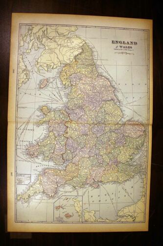


England and Wales Antique Color Map 1901 Cram's 14½" x 22" United Kingdom
Condition:
“This map is in very good condition. This map is folded in the center.”
Price:
US $12.95
ApproximatelyC $17.73
- Buy It NowEngland and Wales Antique Color Map 1901 Cram's 14½" x 22" United Kingdom
Best Offer:
Shipping:
Located in: Corunna, Michigan, United States
Delivery:
Estimated between Tue, May 14 and Thu, May 16 to 43230
Returns:
Payments:
Shop with confidence
Seller assumes all responsibility for this listing.
eBay item number:143789765346
Item specifics
- Seller Notes
- “This map is in very good condition. This map is folded in the center.”
- Cartographer/Publisher
- George F. Cram
- Printing Technique
- Lithography
- Original/Reproduction
- Antique Original
- Publication Year
- 1901
- Format
- Atlas Map
- Two Page Map Single sheet
- 14½" x 22"
- Type
- World Atlas page
- Year
- 1901
- Date Range
- 1900-1909
- Country/Region
- United Kingdom
Item description from the seller
Seller assumes all responsibility for this listing.
eBay item number:143789765346
Shipping and handling
Item location:
Corunna, Michigan, United States
Ships to:
Afghanistan, Albania, Andorra, Armenia, Australia, Austria, Azerbaijan Republic, Bahrain, Bangladesh, Belgium, Bermuda, Bhutan, Bosnia and Herzegovina, Brunei Darussalam, Bulgaria, Cambodia, Canada, China, Cyprus, Czech Republic, Denmark, Estonia, Fiji, Finland, France, Georgia, Germany, Gibraltar, Greece, Greenland, Hong Kong, Hungary, Iceland, India, Indonesia, Ireland, Israel, Japan, Jordan, Kazakhstan, Kiribati, Kuwait, Kyrgyzstan, Laos, Latvia, Lebanon, Liechtenstein, Lithuania, Luxembourg, Macau, Macedonia, Malaysia, Maldives, Malta, Mexico, Moldova, Monaco, Mongolia, Montenegro, Nauru, Nepal, Netherlands, New Zealand, Norway, Oman, Pakistan, Papua New Guinea, Philippines, Poland, Portugal, Qatar, Republic of Croatia, Romania, San Marino, Saudi Arabia, Serbia, Singapore, Slovakia, Slovenia, Solomon Islands, South Korea, Spain, Sri Lanka, Sweden, Switzerland, Taiwan, Tajikistan, Thailand, Tonga, Turkey, Turkmenistan, United Arab Emirates, United Kingdom, United States, Uzbekistan, Vanuatu, Vatican City State, Vietnam, Wallis and Futuna, Western Samoa
Excludes:
Africa, Barbados, Central America and Caribbean, French Guiana, French Polynesia, Guadeloupe, Italy, Libya, Martinique, New Caledonia, Reunion, Russian Federation, South America, Ukraine, Venezuela
| Shipping and handling | To | Service | Delivery*See Delivery notes |
|---|---|---|---|
| US $5.85 (approx C $8.01) | United States | Standard Shipping (USPS First Class®) | Estimated between Tue, May 14 and Thu, May 16 to 43230 |
| Handling time |
|---|
| Will usually ship within 1 business day of receiving cleared payment. |
| Taxes |
|---|
| Taxes may be applicable at checkout. Learn moreLearn more about paying tax on eBay purchases |
Sales tax for an item #143789765346
Sales tax for an item #143789765346
Seller collects sales tax for items shipped to the following provinces:
| Province | Sales Tax Rate |
|---|
Return policy
| After receiving the item, contact seller within | Refund will be given as |
|---|---|
| 30 days after the buyer receives it | Money Back |
The seller is responsible for return shipping costs.
Payment details
Payment methods

Seller feedback (9,628)
k***i (1463)- Feedback left by buyer.
Past 6 months
Verified purchase
Precisely as described; Uber prompt response; Very reasonable pricing; very protective tube packing; reasonable S&H on multiple items; items in 100% condition. Recommend this seller HIGHLY!
e***d (1406)- Feedback left by buyer.
Past 6 months
Verified purchase
As described, freat packaging, good communication, quick delivery, great seller
u***r (1280)- Feedback left by buyer.
Past month
Verified purchase
Item is exactly as described and it was quickly shipped and exceptionally well packaged to prevent any possible damage. I would not hesitate buying from this seller again and I highly recommend samsauctiondepot.
More to explore:
- United Kingdom Antique Europe Maps & Atlases,
- Wales Antique Europe Railroad Maps,
- United Kingdom Antique Europe City Maps,
- Wales Antique Europe Sheet Maps,
- United Kingdom Antique Europe Nautical Maps,
- Wales Antique Europe Maps & Atlases,
- United Kingdom Antique Europe Folding Maps,
- George Cram Antique Wall Maps,
- George Cram Antique Pull Down Maps,
- George Cram City Map Antique Atlas Maps