
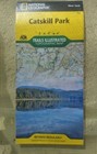
Catskill Park by National Geographic Maps - Trails Illustrated and National...
US $3.57US $3.57
Mon, Jul 28, 12:42 PMMon, Jul 28, 12:42 PM
Picture 1 of 2


Gallery
Picture 1 of 2


Have one to sell?
Catskill Park by National Geographic Maps - Trails Illustrated and National...

US $3.57
ApproximatelyC $4.95
or Best Offer
Was US $6.49 (45% off)
Condition:
Very Good
A book that does not look new and has been read but is in excellent condition. No obvious damage to the cover, with the dust jacket (if applicable) included for hard covers. No missing or damaged pages, no creases or tears, and no underlining/highlighting of text or writing in the margins. May be very minimal identifying marks on the inside cover. Very minimal wear and tear. See the seller’s listing for full details and description of any imperfections.
Ended: Jul 28, 2025 12:42:25 EDT
Oops! Looks like we're having trouble connecting to our server.
Refresh your browser window to try again.
Pickup:
Free local pickup from Vernon-Rockville, Connecticut, United States.
Shipping:
US $4.47 (approx C $6.20) USPS Media MailTM.
Located in: Vernon-Rockville, Connecticut, United States
Delivery:
Estimated between Fri, Aug 29 and Wed, Sep 3 to 94104
Returns:
No returns accepted.
Payments:
Shop with confidence
Seller assumes all responsibility for this listing.
eBay item number:205563622183
Item specifics
- Condition
- Features
- Illustrated
- ISBN
- 9781566955881
About this product
Product Identifiers
Publisher
National Geographic Maps
ISBN-10
1566955882
ISBN-13
9781566955881
eBay Product ID (ePID)
113450648
Product Key Features
Edition
2023
Book Title
Catskill Park
Number of Pages
1 Pages
Language
English
Publication Year
2023
Topic
Maps & Road Atlases (See Also Reference / Atlases, Gazetteers & Maps), Special Interest / Hikes & Walks, United States / Northeast / Middle Atlantic (NJ, NY, Pa)
Illustrator
Yes
Genre
Travel
Book Series
National Geographic Trails Illustrated Map Ser.
Format
Sheet Map, Folded
Dimensions
Item Height
0.3 in
Item Weight
3.3 Oz
Item Length
9.2 in
Item Width
4.2 in
Additional Product Features
Intended Audience
Trade
Series Volume Number
755
Synopsis
- Waterproof - Tear-Resistant - Topographic Map National Geographic's Trails Illustrated map of Catskill Park is designed to meet the needs of outdoor enthusiasts by combining valuable information with unmatched detail of a park that consists of 700,000 acres of beautiful forests, mountains, rivers, and lakes. Created in partnership with the Adirondack Mountain Club (ADK) that provided trail information from its Forest Preserve Series of trail guides, this map will prove invaluable regardless of the season or the reason for your visit. Key areas of interest featured on this map include Ashokan, Pepacton, and Schoharie reservoirs; Belle Ayr Mountain; Slide Mountain Wilderness; Campbell Mountain; and Mongaup Pond. The print version of the map includes an inset of North/South Lake for additional detail. Whatever your chosen activity, the Catskill Park map can guide you off the beaten path and back again with a handy trail chart showing location, mileage, trail use, and difficulty levels for dozens of trails. Mileages between intersections are shown and the map base includes contour lines and elevations for summits, passes and many lakes. The Shawangunk Mountain Scenic Byway is noted for those wishing to take in the scenery by car. Public fishing easements, footbridges, swimming areas, snowmobile parking areas, boat launches, covered bridges, waterfalls, ski areas, and other points of interest are clearly marked. Every Trails Illustrated map is printed on "Backcountry Tough" waterproof, tear-resistant paper. A full UTM grid is printed on the map to aid with GPS navigation. Other features found on this map include: Ashokan Reservoir, Black Dome, Blackhead, Catskill Mountains, Cornell Mountain, Doubletop Mountain, Graham Mountain, Hunter Mountain, Kingston, Peekamoose Mountain, Pepacton Reservoir, Plateau Mountain, Rondout Reservoir, Slide Mountain, Table Mountain, Thomas Cole Mountain, Vly Mountain, Wawarsing, West Kill Mountain. Map Scale = 1:75,000 Sheet Size = 25.5" x 37.75" Folded Size = 4.25" x 9.25", National Geographic's Trails Illustrated Maps are the most detailed and up-to-date topographic recreation maps available for US National Parks, National Forests and other popular outdoor recreation areas. A necessity for exploring the outdoors, each map is printed on waterproof, tear-resistant material. They also contain key safety and contact information, GPS and compass coordinates, Leave No Trace ethical guidelines and hundreds of points-of-interest, including scenic viewpoints, campgrounds, boat launches, swimming areas, marine sanctuaries and wildlife refuges.
Item description from the seller

Seller feedback (7,903)
- e***a (2194)- Feedback left by buyer.Past 6 monthsVerified purchaseHIGHLY RECOMMENDED EBAY SELLER !! MY EBAY PURCHASED ORDER ARRIVED SAFELY PACKAGED AND AS SPECIFIED AND DESCRIBED IN THE LISTING BY THE EBAY SELLER. I RECEIVED OUTSTANDING COMMUNICATIONS AND OVERALL CUSTOMER SERVICE. A TRUE VALUED AND TRUSTED EBAY SELLER IN MY OPINION !! THANK YOU.
- t***1 (62)- Feedback left by buyer.Past 6 monthsVerified purchaseBought two ships from seller and combined the shipping. Packaging was awesome and both ships looked brand new when I got them. Got both ship at a great value and would buy from them again. Communication was amazing with seller. Thank You for offering these ships up for sale. They will go very nice in my collection.Rare! Holland America Line MS Oosterdam 10" Model Cruise Ship Souvenir (#205491047595)
- 3***1 (1823)- Feedback left by buyer.Past 6 monthsVerified purchaseThis seller was so beyond patient with my questions and got back immediately.The prints are exactly as described and packaged well,shipped fast. I would order again anytime. I also would like to say you don't find a great seller like this everyday. Vtsit lemonsandapples and check them out. Thank you
Product ratings and reviews
Most relevant reviews
- Oct 31, 2017
Never Get Lost
Verified purchase: YesCondition: New
- Jun 23, 2020
Excellent map
Verified purchase: YesCondition: NewSold by: studio20
- Sep 25, 2018
useful
Verified purchase: YesCondition: NewSold by: bellaterramaps
- Apr 01, 2020
Map
Verified purchase: YesCondition: NewSold by: ubargain
More to explore:
- National Geographic Maps & Atlases,
- National Geographic Illustrated Atlases,
- Illustrated National Geographic Magazines,
- National Geographic World Maps & Atlases,
- National Geographic Folding Map Maps & Atlases,
- Illustrated History National Geographic Magazines,
- National Geographic Magazines,
- National Geographic Children Magazines,
- National Geographic History Magazines,
- Monthly National Geographic Magazines
Seller feedback (7,903)
- e***a (2194)- Feedback left by buyer.Past 6 monthsVerified purchaseHIGHLY RECOMMENDED EBAY SELLER !! MY EBAY PURCHASED ORDER ARRIVED SAFELY PACKAGED AND AS SPECIFIED AND DESCRIBED IN THE LISTING BY THE EBAY SELLER. I RECEIVED OUTSTANDING COMMUNICATIONS AND OVERALL CUSTOMER SERVICE. A TRUE VALUED AND TRUSTED EBAY SELLER IN MY OPINION !! THANK YOU.
- t***1 (62)- Feedback left by buyer.Past 6 monthsVerified purchaseBought two ships from seller and combined the shipping. Packaging was awesome and both ships looked brand new when I got them. Got both ship at a great value and would buy from them again. Communication was amazing with seller. Thank You for offering these ships up for sale. They will go very nice in my collection.Rare! Holland America Line MS Oosterdam 10" Model Cruise Ship Souvenir (#205491047595)
- 3***1 (1823)- Feedback left by buyer.Past 6 monthsVerified purchaseThis seller was so beyond patient with my questions and got back immediately.The prints are exactly as described and packaged well,shipped fast. I would order again anytime. I also would like to say you don't find a great seller like this everyday. Vtsit lemonsandapples and check them out. Thank you