Picture 1 of 7


Gallery
Picture 1 of 7


Have one to sell?
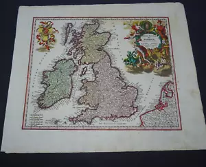
Antique Map of Great Britain by Christoph Weigel 1718

GBP 135.00
ApproximatelyC $248.59
Condition:
- Buy It NowAntique Map of Great Britain by Christoph Weigel 1718
Oops! Looks like we're having trouble connecting to our server.
Refresh your browser window to try again.
Shipping:
GBP 10.00 (approx C $18.41) Royal Mail International Signed.
International shipment of items may be subject to customs processing and additional charges.
Located in: Bath, United Kingdom
Delivery:
Estimated between Thu, Jul 31 and Thu, Aug 7
Returns:
No returns accepted.
Payments:
Shop with confidence
Seller assumes all responsibility for this listing.
eBay item number:255896997658
Item specifics
- Date Range
- 1700-1799
- Type
- Topographical Map
- Printing Technique
- Copper Plate
- Year
- 1718
- Era
- 1700s
- Original/Reproduction
- Antique Original
- Cartographer/Publisher
- Christopher Weigel
- Country/Region
- England, Ireland, Scotland, Wales
Item description from the seller

Seller feedback (483)
- *****- Feedback left by buyer.Past 6 monthsVerified purchaseGreat thank you. Fast shipping, well packaged, item arrived in expected condition as described. x
- 0***1 (1574)- Feedback left by buyer.Past 6 monthsVerified purchaseReceived OK, great map, well packaged, easy transaction, A1.
- o***y (58)- Feedback left by buyer.Past monthVerified purchaseWell packaged and quick dispatch.
More to explore:
- Antique Atlas Maps,
- Silver Antiques Sir Christopher,
- Antique Original Political Map Antique Wall Maps,
- Antique Original City Map Antique Atlas Maps,
- Antique Original Topographical Map Antique Wall Maps,
- Antique Original County Map Antique School Maps,
- Antique Original River Map Antique Folding Maps,
- Antique Original Geological Map Antique Atlas Maps,
- Antique Original Political Map Antique Sheet Maps,
- Antique Original Novelty Map Antique Atlas Maps
Seller feedback (483)
- *****- Feedback left by buyer.Past 6 monthsVerified purchaseGreat thank you. Fast shipping, well packaged, item arrived in expected condition as described. x
- 0***1 (1574)- Feedback left by buyer.Past 6 monthsVerified purchaseReceived OK, great map, well packaged, easy transaction, A1.
- o***y (58)- Feedback left by buyer.Past monthVerified purchaseWell packaged and quick dispatch.