Picture 1 of 4


Gallery
Picture 1 of 4


Have one to sell?
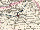
1869 Hand Colored Map of the EURE et LOIRE DEPARTMENT in FRANCE by Vuillemin

US $12.95
ApproximatelyC $17.82
or Best Offer
Condition:
- Buy It Now1869 Hand Colored Map of the EURE et LOIRE DEPARTMENT in FRANCE by Vuillemin
Oops! Looks like we're having trouble connecting to our server.
Refresh your browser window to try again.
Shipping:
US $4.00 (approx C $5.50) USPS First Class®.
Located in: Hawthorne, California, United States
Delivery:
Estimated between Thu, Aug 14 and Thu, Aug 21 to 94104
Returns:
14 days return. Buyer pays for return shipping. If you use an eBay shipping label, it will be deducted from your refund amount.
Payments:
Shop with confidence
Seller assumes all responsibility for this listing.
eBay item number:263108366598
Item specifics
- Type
- County Map
- Year
- 1869
- Country/Region
- France
- State
- Loire
- County
- Loire
- Format
- Atlas Map
- Cartographer/Publisher
- Vuillemin
- Original/Reproduction
- Antique Original
Item description from the seller

Seller feedback (1,992)
- 0***1 (441)- Feedback left by buyer.More than a year agoVerified purchaseAs described, quick delivery and well packaged. Thank you.1903 Color Map of IRELAND - Pre Independance under British control (#264942143308)
- g***a (1386)- Feedback left by buyer.More than a year agoVerified purchaseArrived exactly as described. Great seller. Thank you. Will buy from again.1902 Color Map of TURKEY in EUROPE - Inset of Constantinople (#262119681396)
- 5***5 (1412)- Feedback left by buyer.More than a year agoVerified purchaseAs described, fast ship, A+ sellerILLUSTRATED LONDON NEWS 13 Issues - from 1853 CRIMEAN WAR - Outstanding (#265075389306)
More to explore:
- Paris France Antique Maps,
- France City Map Antique Europe Atlas Maps,
- France Topographical Map Antique Europe Atlas Maps,
- France County Map Antique Europe Atlas Maps,
- France Political Map Antique Europe Atlas Maps,
- France Antique Europe Topographical Maps,
- France Antique Europe Folding Maps,
- Paris France Antique Europe County Maps,
- Antique European Maps & Atlases Leipzig France,
- France Lithography Antique Europe Topographical Maps
Seller feedback (1,992)
- 0***1 (441)- Feedback left by buyer.More than a year agoVerified purchaseAs described, quick delivery and well packaged. Thank you.1903 Color Map of IRELAND - Pre Independance under British control (#264942143308)
- g***a (1386)- Feedback left by buyer.More than a year agoVerified purchaseArrived exactly as described. Great seller. Thank you. Will buy from again.1902 Color Map of TURKEY in EUROPE - Inset of Constantinople (#262119681396)
- 5***5 (1412)- Feedback left by buyer.More than a year agoVerified purchaseAs described, fast ship, A+ sellerILLUSTRATED LONDON NEWS 13 Issues - from 1853 CRIMEAN WAR - Outstanding (#265075389306)