
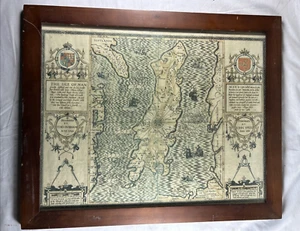
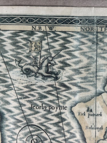
Antique Illustrated 1595 MEDIEVAL MAP of THE ISLE OF MAN
US $239.39US $239.39
Sat, Aug 09, 09:22 PMSat, Aug 09, 09:22 PM
Picture 1 of 10


Gallery
Picture 1 of 10


Have one to sell?
Antique Illustrated 1595 MEDIEVAL MAP of THE ISLE OF MAN
US $239.39
ApproximatelyC $330.43
Best offer accepted
or Best Offer
Condition:
“GOOD AS SHOWN CONDITION”
Oops! Looks like we're having trouble connecting to our server.
Refresh your browser window to try again.
Shipping:
US $40.00 (approx C $55.21) Economy Shipping.
Located in: Union Dale, Pennsylvania, United States
Delivery:
Estimated between Tue, Sep 16 and Mon, Sep 22 to 94104
Returns:
30 days return. Buyer pays for return shipping. If you use an eBay shipping label, it will be deducted from your refund amount.
Payments:
Shop with confidence
Seller assumes all responsibility for this listing.
eBay item number:267120158288
Item specifics
- Seller Notes
- “GOOD AS SHOWN CONDITION”
- Date Range
- 1500-1599
- Type
- Pictorial/Bird's Eye
- Format
- Wall Map
- Original/Reproduction
- Vintage Reproduction
- Cartographer/Publisher
- Tho Durham
- City
- Isle of Man
- Country/Region
- Scotland, United Kingdom
- County
- Isle of Man
Item description from the seller
Seller Feedback
No feedback yet
More to explore:
- Antique European Maps & Atlases Isle of Wight,
- Isle of Wight Antique Original Antique Europe Maps & Atlases,
- England Isle of Wight Antique Europe Maps & Atlases,
- Isle of Wight 1800-1899 Date Range Antique Europe Maps & Atlases,
- Antique Atlas Maps,
- Antique Original River Map Antique Folding Maps,
- Antique Original County Map Antique Atlas Maps,
- Antique Original Topographical Map Antique Atlas Maps,
- Antique Original County Map Antique Wall Maps,
- Antique Original City Map Antique Sheet Maps