
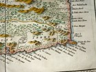
SAINT LUCIA ISLAND 1758 NICOLAS BELLIN NICE ANTIQUE MAP IN COLORS 18TH CENTURY
US $200.00US $200.00
Sun, Mar 31, 02:17 PMSun, Mar 31, 02:17 PM
Picture 1 of 10


Gallery
Picture 1 of 10


Have one to sell?
SAINT LUCIA ISLAND 1758 NICOLAS BELLIN NICE ANTIQUE MAP IN COLORS 18TH CENTURY
US $200.00
ApproximatelyC $274.52
Best offer accepted
or Best Offer
Condition:
“very good condition”
Oops! Looks like we're having trouble connecting to our server.
Refresh your browser window to try again.
Shipping:
US $30.00 (approx C $41.18) FedEx Express Saver®.
International shipment of items may be subject to customs processing and additional charges.
Located in: Paris, France
Delivery:
Estimated between Thu, Jul 24 and Fri, Jul 25 to 94104
Returns:
14 days return. Buyer pays for return shipping. If you use an eBay shipping label, it will be deducted from your refund amount.
Payments:
Shop with confidence
Seller assumes all responsibility for this listing.
eBay item number:284763753602
Item specifics
- Seller Notes
- “very good condition”
- Cartographer/Publisher
- Jacques Nicholas Bellin
- Printing Technique
- Copper Plate
- Original/Reproduction
- Antique Original
- Format
- Atlas Map
- Year
- 1758
- Date Range
- 1700-1799
- Country/Region
- Saint Lucia
Item description from the seller
Seller business information
VAT number: FR 12429203854
Seller Feedback
No feedback yet
This is a private listing and your identity will not be disclosed to anyone except the seller.
More to explore:
- Saint Lucia Antique Central America/Caribbean Maps & Atlases,
- Jacques Nicholas Bellin Antique County Maps,
- Jacques Nicholas Bellin Antique Folding Maps,
- Jacques Nicholas Bellin Antique Atlas Maps,
- Jacques Nicholas Bellin Antique Africa County Maps,
- Jacques Nicholas Bellin Antique Asia County Maps,
- Jacques Nicholas Bellin China Antique Asian Maps & Atlases,
- 18th Century,
- Jacques Nicholas Bellin Copper Plate Antique Asia Maps & Atlases,
- Jacques Nicholas Bellin 1700-1799 Date Range Antique Maps, Atlases & Globes