Picture 1 of 24


Gallery
Picture 1 of 24


Have one to sell?
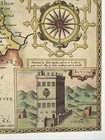
3 x Old Antique Vintage maps Derbyshire, England: 1600's & 1800's: Reprint
GBP 12.00
ApproximatelyC $22.48
Condition:
“These maps are book plates taken very carefully from 3 different book of maps printed in 1980's and ”... Read moreabout condition
- Buy It Now3 x Old Antique Vintage maps Derbyshire, England: 1600's & 1800's: Reprint
Oops! Looks like we're having trouble connecting to our server.
Refresh your browser window to try again.
Shipping:
GBP 19.24 (approx C $36.04) International Priority Shipping to United States via eBay's Global Shipping Program.
Located in: Sheffield, United Kingdom
Import charges:
Free amount confirmed at checkout
Delivery:
Estimated between Fri, Aug 29 and Mon, Sep 8
Includes international tracking
Returns:
No returns accepted.
Payments:
Shop with confidence
Seller assumes all responsibility for this listing.
eBay item number:305836086275
Item specifics
- Seller Notes
- Antique
- Yes
- Date Range
- 1600-1699
- Type
- County Map
- Format
- Wall/ Poster Map
- Year
- 1610, 1830, 1840
- Era
- 1800s
- Cartographer/Publisher
- John Speed
- Original/Reproduction
- Antique Reproduction
- Country/Region
- England
- County
- Derbyshire
- Map Type
- Countries/ Borders
- Antique/ Modern
- Antique
Item description from the seller
Seller feedback (3,319)
- *****- Feedback left by buyer.Past 6 monthsVerified purchaseExcellent transaction. Map was as described, well packaged and delivered on time Recommended seller
- *****- Feedback left by buyer.Past 6 monthsVerified purchaseAs described. Well protected with cardboard in envelope for international mail England to Australia. Seller recommended. Thanks A+
- *****- Feedback left by buyer.Past 6 monthsVerified purchaseItem exactly as described, quick dispatch and delivery. Overall, excellent service from this highly recommended seller.Buy with 100% confidence !
This is a private listing and your identity will not be disclosed to anyone except the seller.
More to explore:
- Antique European Maps & Atlases England 1600-1699 Date Range,
- England 1600-1699 Date Range Antique Europe Folding Maps,
- England 1600-1699 Date Range Antique Europe County Maps,
- England 1800-1899 Date Range Antique Europe Sheet Maps,
- England 1800-1899 Date Range Antique Europe County Maps,
- England Antique Europe Maps & Atlases,
- England European Antique Maps & Atlases Middlesex 1800-1899 Date Range,
- England European Antique Maps & Atlases Nottinghamshire 1800-1899 Date Range,
- Liverpool England Antique European Maps & Atlases 1800-1899 Date Range,
- Dover England Antique European Maps & Atlases 1800-1899 Date Range