Picture 1 of 2

Gallery
Picture 1 of 2


Have one to sell?
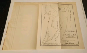
1913 ST. CLAIR RIVER AT PORT HURON MICHIGAN ENGINEERING MAP 7.75 X 9!

US $9.99
ApproximatelyC $13.80
Condition:
“Map is in Very Good Condition!”
- Buy It Now1913 ST. CLAIR RIVER AT PORT HURON MICHIGAN ENGINEERING MAP 7.75 X 9!
Oops! Looks like we're having trouble connecting to our server.
Refresh your browser window to try again.
Shipping:
US $5.50 (approx C $7.60) Standard Shipping.
Located in: Dayton, Ohio, United States
Delivery:
Estimated between Tue, Sep 9 and Sat, Sep 13 to 94104
Returns:
No returns accepted.
Payments:
Shop with confidence
Seller assumes all responsibility for this listing.
eBay item number:326531074240
Item specifics
- Seller Notes
- “Map is in Very Good Condition!”
- Date Range
- 1910-1919
- Type
- River Map
- US State
- Michigan
- Format
- Folding Map
- Year
- 1913
- Original/Reproduction
- Antique Original
- Country/Region
- United States of America
Item description from the seller

Seller feedback (7,982)
- r***r (82)- Feedback left by buyer.Past 6 monthsVerified purchaseGreat communication with seller. Package arrived quickly and was well packaged. My item was as described and I am thrilled with my purchase. Price was fair for my item and I would recommend this seller!1914 ENTRANCE TO COOS BAY OREGON ENGINEERING MAP 17 x 35! (#355481357854)
- 2***2 (505)- Feedback left by buyer.Past 6 monthsVerified purchaseThanks for the prompt shipment and excellent service as always. Life magazine is in great condition and definitely fits the description. This seller always is professional and packages very well. Defineltly will do business again.
- a***w (3582)- Feedback left by buyer.Past 6 monthsVerified purchaseNice cover, good price, exactly as described, fast delivery and well packaged, perfect transaction, great eBay seller
More to explore:
- Michigan River Map Antique North America Folding Maps,
- Michigan Antique North America River Maps,
- St. Louis Antique North America River Maps,
- River Map Antique Folding Maps,
- River Map Antique Sheet Maps,
- Antique North America Michigan Maps,
- Antique Asia River Maps,
- Lithography River Map Antique Sheet Maps,
- Lithography Antique River Maps,
- London Antique Europe River Maps
Seller feedback (7,982)
- r***r (82)- Feedback left by buyer.Past 6 monthsVerified purchaseGreat communication with seller. Package arrived quickly and was well packaged. My item was as described and I am thrilled with my purchase. Price was fair for my item and I would recommend this seller!1914 ENTRANCE TO COOS BAY OREGON ENGINEERING MAP 17 x 35! (#355481357854)
- 2***2 (505)- Feedback left by buyer.Past 6 monthsVerified purchaseThanks for the prompt shipment and excellent service as always. Life magazine is in great condition and definitely fits the description. This seller always is professional and packages very well. Defineltly will do business again.
- a***w (3582)- Feedback left by buyer.Past 6 monthsVerified purchaseNice cover, good price, exactly as described, fast delivery and well packaged, perfect transaction, great eBay seller