
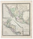
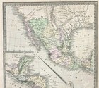
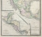
1848 MEXICO - REPUBLIC OF TEXAS Map ORIGINAL Jeremiah Greenleaf (12X10)
US $223.20US $223.20
Thu, Jul 03, 12:03 PMThu, Jul 03, 12:03 PM
Picture 1 of 7


Gallery
Picture 1 of 7


Have one to sell?
1848 MEXICO - REPUBLIC OF TEXAS Map ORIGINAL Jeremiah Greenleaf (12X10)
US $223.20
ApproximatelyC $307.88
or Best Offer
Was US $248.00 (10% off)
Condition:
Ended: Jul 03, 2025 12:03:06 EDT
Oops! Looks like we're having trouble connecting to our server.
Refresh your browser window to try again.
Shipping:
Free USPS Ground Advantage®.
Located in: Carefree, Arizona, United States
Delivery:
Estimated between Mon, Sep 8 and Fri, Sep 12 to 94104
Returns:
30 days return. Seller pays for return shipping.
Payments:
Shop with confidence
Seller assumes all responsibility for this listing.
eBay item number:326627440916
Item specifics
- Date Range
- 1800-1899
- Type
- Political Map
- US State
- Texas
- Format
- Atlas Map
- Printing Technique
- Copper Plate
- Year
- 1848
- Canadian Province
- Quebec
- Original/Reproduction
- Antique Original
- Cartographer/Publisher
- Jeremiah Greenleaf
- City
- AUSTIN
- Country/Region
- Mexico
Item description from the seller
Seller Feedback
No feedback yet
More to explore:
- Mexico Texas Antique Original Antique North American Maps & Atlases,
- Mexico Texas Antique North American Maps & Atlases,
- Mexico New Mexico Vintage Original Antique North America Maps & Atlases,
- Mexico Vintage Original Antique North American Maps & Atlases,
- Mexico Antique Original Antique North America Atlas Maps,
- Texas Antique Original Antique North America Railroad Maps,
- Mexico Lithography Antique Original Antique North American Maps & Atlases,
- New Mexico Vintage Original Antique North America Maps & Atlases,
- New Mexico Antique Original Antique North America Topographical Maps,
- Mexico New Mexico Antique North America Maps & Atlases