Picture 1 of 3


Gallery
Picture 1 of 3


Have one to sell?
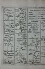
WILTSHIRE, SALISBURY, MARLBOROUGH, Pl 93, antique road map, Jefferys, 1775

GBP 33.50
ApproximatelyC $62.49
Condition:
“Very good condition. Light age toning. One or two very faint age spots. Well suited for framing and ”... Read moreabout condition
- Buy It NowWILTSHIRE, SALISBURY, MARLBOROUGH, Pl 93, antique road map, Jefferys, 1775
Oops! Looks like we're having trouble connecting to our server.
Refresh your browser window to try again.
Returns:
30 days return. Buyer pays for return shipping. If you use an eBay shipping label, it will be deducted from your refund amount.
Payments:
Shop with confidence
Seller assumes all responsibility for this listing.
eBay item number:335858681818
Item specifics
- Seller Notes
- County
- Gloucestershire, Oxfordshire, Wiltshire
- Cartographer/Publisher
- Thomas Jefferys
- Printing Technique
- Copper Plate
- Date Range
- 1700-1799
- Original/Reproduction
- Antique Original
- Country/Region
- England
- Era
- 1700s
- Format
- Atlas Map
- Type
- Road Atlas Map
- Year
- 1775
Item description from the seller

Seller feedback (2,541)
- e***a (70)- Feedback left by buyer.Past 6 monthsVerified purchaseI am giving this purchase a 5-star rating, even though the map arrived more than a month late & the shipping tube had been severely mangled (no damage to the contents). Neither problem was the Seller's fault. The shipment was held by US Customs for a month (visible on the tracking documents) without explanation or contact. Seller remained in regular contact, offered to, and then refunded full purchase price during this hiatus. Upon successful delivery, Seller re-invoiced for the map, & I paid.Original antique atlas map BRITISH ISLES, GREAT BRITAIN, IRELAND, E Bowen, 1747 (#335916077525)
- 1***1 (700)- Feedback left by buyer.Past 6 monthsVerified purchaseReceived very quickly and well packaged. Item as described, excellent seller.
- r***o (2730)- Feedback left by buyer.Past yearVerified purchaseGreat Seller - This map arrived exactly as described it will be a great addition for my Ancestry research. The map arrived very well packaged and rolled carefully and placed into a postal tube. The delivery was well within the estimated time. I would have no hesitation in recommending this seller to any potential buyers - THANK YOU.PLYMOUTH, DEVONPORT, CITY PLAN, STREET PLAN, original antique map, Bacon, 1884 (#235500514934)
More to explore:
- Antique European Maps & Atlases Wiltshire,
- Wiltshire Antique Original Antique European Maps & Atlases,
- Antique European Maps & Atlases England Wiltshire,
- Thomas Jefferys Antique Maps, Atlases & Globes,
- Antique European Maps & Atlases Wiltshire 1800-1899 Date Range,
- England European Antique Maps & Atlases Wiltshire 1800-1899 Date Range,
- Marlborough 1900-1940 Silver Antiques,
- Reed & Barton Marlborough Silver Antiques,
- Marlborough US Sterling Silver Antiques,
- Reed & Barton Antique US Sterling Silver Marlborough
Seller feedback (2,541)
- e***a (70)- Feedback left by buyer.Past 6 monthsVerified purchaseI am giving this purchase a 5-star rating, even though the map arrived more than a month late & the shipping tube had been severely mangled (no damage to the contents). Neither problem was the Seller's fault. The shipment was held by US Customs for a month (visible on the tracking documents) without explanation or contact. Seller remained in regular contact, offered to, and then refunded full purchase price during this hiatus. Upon successful delivery, Seller re-invoiced for the map, & I paid.Original antique atlas map BRITISH ISLES, GREAT BRITAIN, IRELAND, E Bowen, 1747 (#335916077525)
- 1***1 (700)- Feedback left by buyer.Past 6 monthsVerified purchaseReceived very quickly and well packaged. Item as described, excellent seller.
- r***o (2730)- Feedback left by buyer.Past yearVerified purchaseGreat Seller - This map arrived exactly as described it will be a great addition for my Ancestry research. The map arrived very well packaged and rolled carefully and placed into a postal tube. The delivery was well within the estimated time. I would have no hesitation in recommending this seller to any potential buyers - THANK YOU.PLYMOUTH, DEVONPORT, CITY PLAN, STREET PLAN, original antique map, Bacon, 1884 (#235500514934)