Picture 1 of 6


Gallery
Picture 1 of 6


Have one to sell?
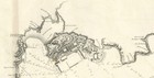
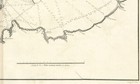
Map "Plano de la Ría y Puerto de Ferrol" (Spain) Dirección de Hidrografía, 1789

GBP 400.00
ApproximatelyC $734.15
or Best Offer
Condition:
- Buy It NowMap "Plano de la Ría y Puerto de Ferrol" (Spain) Dirección de Hidrografía, 1789
Oops! Looks like we're having trouble connecting to our server.
Refresh your browser window to try again.
Shipping:
GBP 18.00 (approx C $33.04) International Tracked Postage.
International shipment of items may be subject to customs processing and additional charges.
Located in: London, United Kingdom
Delivery:
Estimated between Mon, Aug 11 and Fri, Aug 15 to 94104
Returns:
No returns accepted.
Payments:
Shop with confidence
Seller assumes all responsibility for this listing.
eBay item number:335877683533
Item specifics
- Date Range
- 1700-1799
- Antique
- Yes
- Type
- Nautical Map
- Format
- Sheet Map
- Year
- 1789
- Era
- 1700s
- Cartographer/Publisher
- Brigadier Vicente Tofiño de San Miguel / Dirección de Hidrografía
- Original/Reproduction
- Antique Original
- City
- Ferrol
- Country/Region
- Spain
Item description from the seller

Popular categories from this store
Seller feedback (303)
- e***2 (1298)- Feedback left by buyer.Past 6 monthsVerified purchaseExquisite 18th century depiction and gravure of the legendary Bastille by one of the greatest artists of the period and the engraver. Offered at a price point which was generous and more than affordable. This gravure was professionally, expertly packaged—which is a distinct pleasure. It is always pleasing to deal with a professional business in antiquities, as they possess the knowledge in handling fragile, irreplaceable, historical art. Sent securely by Fedex, arriving very quickly. Recommended
- f***5 (5)- Feedback left by buyer.Past 6 monthsVerified purchaseQuickly shipped, very well packaged with supporting internal card and plastic. As described and in good condition. Thank you once more. Comes once more with a certificate of authenticity, which is very much appreciated. This is my second map from this gallery and probably won't be the last. Highly recommended.Map "Southern Alps of New Zealand" Royal Geographical Society, 1910 (#334963326798)
- u***i (150)- Feedback left by buyer.Past 6 monthsVerified purchaseItem as described. Packed well with fast shipping. In good condition for its age! Would buy from this seller again.Antique Map "Carta delle Isole Pelew" (Palau/Philippines) Anon, c.1790 (#335166770898)
More to explore:
- Antique European Maps & Atlases Guillaume De L'Isle,
- Guillaume De L'Isle Antique Maps, Atlases & Globes,
- Rio de Janeiro Antique South America Atlas Maps,
- Guillaume De L'Isle Antique Original Antique Maps, Atlases & Globes,
- Guillaume De L'Isle Copper Plate Antique Europe Maps & Atlases,
- Antique Blanc De Chine Vases,
- Fleur de Lis Antique Finials,
- DC, DE, MD, NJ, NY, PA Antique North America Wall Maps,
- Antique Blanc De Chine Figurines & Statues,
- Woodcut DC, DE, MD, NJ, NY, PA Antique North America Wall Maps
Popular categories from this store
Seller feedback (303)
- e***2 (1298)- Feedback left by buyer.Past 6 monthsVerified purchaseExquisite 18th century depiction and gravure of the legendary Bastille by one of the greatest artists of the period and the engraver. Offered at a price point which was generous and more than affordable. This gravure was professionally, expertly packaged—which is a distinct pleasure. It is always pleasing to deal with a professional business in antiquities, as they possess the knowledge in handling fragile, irreplaceable, historical art. Sent securely by Fedex, arriving very quickly. Recommended
- f***5 (5)- Feedback left by buyer.Past 6 monthsVerified purchaseQuickly shipped, very well packaged with supporting internal card and plastic. As described and in good condition. Thank you once more. Comes once more with a certificate of authenticity, which is very much appreciated. This is my second map from this gallery and probably won't be the last. Highly recommended.Map "Southern Alps of New Zealand" Royal Geographical Society, 1910 (#334963326798)
- u***i (150)- Feedback left by buyer.Past 6 monthsVerified purchaseItem as described. Packed well with fast shipping. In good condition for its age! Would buy from this seller again.Antique Map "Carta delle Isole Pelew" (Palau/Philippines) Anon, c.1790 (#335166770898)