
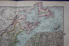
Original antique map EAST USA, ATLANTIC STATES, MAINE, VIRGINIA, Stieler, 1891
GBP 19.99GBP 19.99
Sun, Jul 20, 08:01 AMSun, Jul 20, 08:01 AM
Picture 1 of 7


Gallery
Picture 1 of 7


Have one to sell?
Original antique map EAST USA, ATLANTIC STATES, MAINE, VIRGINIA, Stieler, 1891

Condition:
“Very good condition, light age toning and one or two faint age spots. Centrefold as published. ”... Read moreabout condition
Ended: Jul 20, 2025 08:01:54 EDT
Oops! Looks like we're having trouble connecting to our server.
Refresh your browser window to try again.
Shipping:
GBP 10.00 (approx C $18.73) Royal Mail International Tracked.
International shipment of items may be subject to customs processing and additional charges.
Located in: Ilkley, United Kingdom
Delivery:
Estimated between Thu, Aug 21 and Thu, Aug 28 to 94104
Returns:
30 days return. Buyer pays for return shipping. If you use an eBay shipping label, it will be deducted from your refund amount.
Payments:
Shop with confidence
Seller assumes all responsibility for this listing.
eBay item number:336064256743
Item specifics
- Seller Notes
- Cartographer/Publisher
- Adolf Stieler
- Printing Technique
- Copper Plate
- Date Range
- 1800-1899
- Original/Reproduction
- Antique Original
- Country/Region
- United States of America
- Canadian Province
- Northwest Territories
- Era
- 1800s
- Format
- Atlas Map
- Type
- Topographical Map
- Year
- 1891
Item description from the seller

Seller feedback (2,536)
- e***a (70)- Feedback left by buyer.Past 6 monthsVerified purchaseI am giving this purchase a 5-star rating, even though the map arrived more than a month late & the shipping tube had been severely mangled (no damage to the contents). Neither problem was the Seller's fault. The shipment was held by US Customs for a month (visible on the tracking documents) without explanation or contact. Seller remained in regular contact, offered to, and then refunded full purchase price during this hiatus. Upon successful delivery, Seller re-invoiced for the map, & I paid.Original antique atlas map BRITISH ISLES, GREAT BRITAIN, IRELAND, E Bowen, 1747 (#335916077525)
- 1***1 (700)- Feedback left by buyer.Past monthVerified purchaseReceived very quickly and well packaged. Item as described, excellent seller.
- r***o (2729)- Feedback left by buyer.Past yearVerified purchaseGreat Seller - This map arrived exactly as described it will be a great addition for my Ancestry research. The map arrived very well packaged and rolled carefully and placed into a postal tube. The delivery was well within the estimated time. I would have no hesitation in recommending this seller to any potential buyers - THANK YOU.PLYMOUTH, DEVONPORT, CITY PLAN, STREET PLAN, original antique map, Bacon, 1884 (#235500514934)
More to explore:
- Adolf Stieler Antique Original Antique Maps, Atlases & Globes,
- Adolf Stieler Antique Maps, Atlases & Globes,
- United States of America Maine Antique Original Antique North American Maps & Atlases,
- United States of America West Virginia Antique Original Antique North America Maps & Atlases,
- Virginia Antique Original Antique North America Atlas Maps,
- Virginia Antique Original Antique North America Folding Maps,
- Maine Antique Original Antique North America Wall Maps,
- Maine Antique Original Antique North America County Maps,
- West Virginia Antique Original Antique North America Folding Maps,
- Virginia Vintage Original Antique North America Topographical Maps
Seller feedback (2,536)
- e***a (70)- Feedback left by buyer.Past 6 monthsVerified purchaseI am giving this purchase a 5-star rating, even though the map arrived more than a month late & the shipping tube had been severely mangled (no damage to the contents). Neither problem was the Seller's fault. The shipment was held by US Customs for a month (visible on the tracking documents) without explanation or contact. Seller remained in regular contact, offered to, and then refunded full purchase price during this hiatus. Upon successful delivery, Seller re-invoiced for the map, & I paid.Original antique atlas map BRITISH ISLES, GREAT BRITAIN, IRELAND, E Bowen, 1747 (#335916077525)
- 1***1 (700)- Feedback left by buyer.Past monthVerified purchaseReceived very quickly and well packaged. Item as described, excellent seller.
- r***o (2729)- Feedback left by buyer.Past yearVerified purchaseGreat Seller - This map arrived exactly as described it will be a great addition for my Ancestry research. The map arrived very well packaged and rolled carefully and placed into a postal tube. The delivery was well within the estimated time. I would have no hesitation in recommending this seller to any potential buyers - THANK YOU.PLYMOUTH, DEVONPORT, CITY PLAN, STREET PLAN, original antique map, Bacon, 1884 (#235500514934)