Picture 1 of 2


Gallery
Picture 1 of 2

Have one to sell?
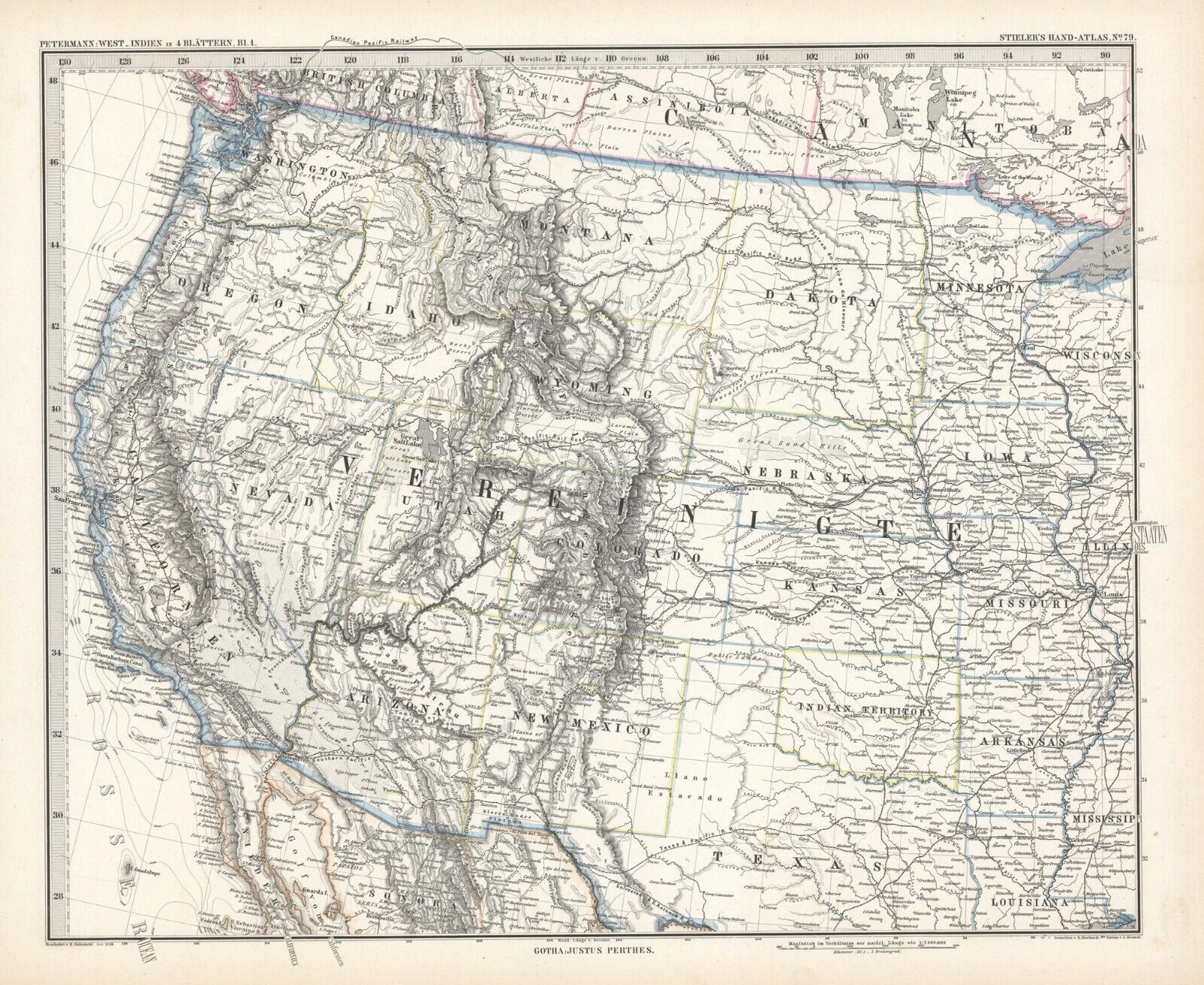
1884 Steiler Map: USA west of 90 Deg.
![Pacific Shore [Collectible] Maps](https://i.ebayimg.com/images/g/ti0AAOSwdIZdwbZo/s-l64.jpg)
US $25.00
ApproximatelyC $34.67
Condition:
“VG,”
- Buy It Now1884 Steiler Map: USA west of 90 Deg.
Oops! Looks like we're having trouble connecting to our server.
Refresh your browser window to try again.
Shipping:
US $9.69 (approx C $13.44) USPS Ground Advantage®.
Located in: San Diego, California, United States
Delivery:
Estimated between Sat, Aug 23 and Fri, Aug 29 to 94104
Returns:
14 days return. Buyer pays for return shipping. If you use an eBay shipping label, it will be deducted from your refund amount.
Payments:
Shop with confidence
Seller assumes all responsibility for this listing.
eBay item number:354101884650
Item specifics
- Seller Notes
- “VG,”
- Date Range
- 1800-1899
- Format
- Atlas Map
- Printing Technique
- Lithography
- Year
- 1884
- Original/Reproduction
- Antique Original
Item description from the seller
![Pacific Shore [Collectible] Maps](https://i.ebayimg.com/images/g/ti0AAOSwdIZdwbZo/s-l140.jpg)
Seller feedback (3,124)
- h***m (1117)- Feedback left by buyer.Past monthVerified purchaseFast ship, nicely packaged, nice map, great seller!!!! AAAAA
- u***e (75)- Feedback left by buyer.Past 6 monthsVerified purchaseThe map was well packaged and shipped quickly. Map was as described. Colors were as shown. Thanks!
- 5***7 (1713)- Feedback left by buyer.Past 6 monthsVerified purchaseexcellent seller comunication1910 SOUTH DAKOTA (#373438601661)
More to explore:
- West Virginia Topographical Map Antique North America Folding Maps,
- West Virginia Antique North America Maps & Atlases,
- West Virginia Antique North America Topographical Maps,
- West Virginia Antique North America Folding Maps,
- West Virginia Antique North America Railroad Maps,
- Richmond West Virginia Antique North America Maps & Atlases,
- George Cram West Virginia Antique North America Maps & Atlases,
- West Virginia 1800-1899 Date Range Antique North America Railroad Maps,
- United States of America Lithography West Virginia Antique North America Maps & Atlases,
- West Virginia Antique North American Maps & Atlases 1930-1939 Date Range
Seller feedback (3,124)
- h***m (1117)- Feedback left by buyer.Past monthVerified purchaseFast ship, nicely packaged, nice map, great seller!!!! AAAAA
- u***e (75)- Feedback left by buyer.Past 6 monthsVerified purchaseThe map was well packaged and shipped quickly. Map was as described. Colors were as shown. Thanks!
- 5***7 (1713)- Feedback left by buyer.Past 6 monthsVerified purchaseexcellent seller comunication1910 SOUTH DAKOTA (#373438601661)