Picture 1 of 2

Picture 1 of 2


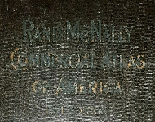
**1921 - 20" x 14" Map ~ BOSTON - CHARLESTON - CAMBRIDGE ~ Free S&H

US $27.15
ApproximatelyC $36.86
or Best Offer
Was US $28.88 (6% off)
Condition:
“Always Quick N Free S&H ~ Reasonable offers are always considered. Browse through over 4000 Rare, ”... Read moreabout condition
Ended: Jul 27, 2024 15:06:58 EDT
Shipping:
Free USPS Ground Advantage®.
Located in: San Antonio, Texas, United States
Delivery:
Estimated between Mon, Sep 30 and Fri, Oct 4 to 43230
Returns:
30 days return. Buyer pays for return shipping.
Payments:
Shop with confidence
Seller assumes all responsibility for this listing.
eBay item number:404858349305
Item specifics
- Seller Notes
- Cartographer/Publisher
- Rand McNally & Co.
- Original/Reproduction
- Vintage Original
- Format
- Atlas Map
- Ref#
- McNALLY1921/050222
- Authentic
- Original map printed in 1921.
- Frame
- Suitable for Framing.
- Type
- Political Map
- Year
- 1921
- US State
- United States, Massachusetts, CT, MA, ME, NH, RI, VT
- City
- Boston
- Date Range
- 1920-1929
- Country/Region
- United States of America
Item description from the seller

More to explore:
- Charleston Antique North America City Maps,
- Charleston Antique North America Folding Maps,
- Antique North American Maps & Atlases Charleston,
- Charleston Antique North America Atlas Maps,
- Charleston Antique North America County Maps,
- Antique European Maps & Atlases Cambridge,
- North Carolina Charleston Antique North America Maps & Atlases,
- Charleston West Virginia Antique North America Atlas Maps,
- Boston City Map Antique North America Atlas Maps,
- Antique North American Maps & Atlases Boston