Picture 1 of 4


Gallery
Picture 1 of 4


Have one to sell?
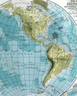
1897 Century Physical World Map South Pole Mountains Asia Europe America Africa

US $39.99
ApproximatelyC $55.34
or Best Offer
Condition:
“Very Good to Excellent condition, on a 12 by 16 1/2" page (30x42cm), see the pics and description ”... Read moreabout condition
- Buy It Now1897 Century Physical World Map South Pole Mountains Asia Europe America Africa
Oops! Looks like we're having trouble connecting to our server.
Refresh your browser window to try again.
Shipping:
US $4.99 (approx C $6.91) USPS Ground Advantage®.
Located in: Fairview, Pennsylvania, United States
Delivery:
Estimated between Sat, Aug 30 and Fri, Sep 5 to 94104
Returns:
30 days return. Seller pays for return shipping.
Payments:
Shop with confidence
Seller assumes all responsibility for this listing.
eBay item number:405403362878
Item specifics
- Seller Notes
- Engraver
- Matthews-Northrup Co.
- Date Range
- 1800-1899
- Type
- Physical Map
- Format
- Atlas Map
- Printing Technique
- Lithography
- Year
- 1897
- Map View
- World
- Original/Reproduction
- Antique Original
- Cartographer/Publisher
- The Century Co.
Item description from the seller

Seller feedback (19,906)
- 1***m (14)- Feedback left by buyer.Past 6 monthsVerified purchaseVendor good to deal with, second or third time I have bought from them. Item as descried and in good condition Safely packed Delivery time good. Recommend vendor
- l***4 (133)- Feedback left by buyer.Past 6 monthsVerified purchaseVery nice. Received as seller described on their web site. It was well packaged and at a decent cost. Seller was good at communication and is willing to work with the customer.1857 Morse Map North Carolina Cape Hatteras Raleigh Durham Asheville Beaufort NC (#365504242256)
- u***g (42)- Feedback left by buyer.Past 6 monthsVerified purchaseGreat seller! Packaged safely and shipped quickly. Great communicator and very knowledgeable. Everything showed up exactly as decribed. Incredible value. 12/10 recommendWest Point WWII Map Operation in Italy Allied Advances from Jan 1944 to Jan 1945 (#365096664387)
More to explore:
- Antique South America Physical Maps,
- Physical Map Antique South America Atlas Maps,
- Lithography Antique South America Physical Maps,
- Antique Africa Physical Maps,
- Antique Europe Physical Maps,
- Antique Original Antique South America Physical Maps,
- Germany Antique Europe Physical Maps,
- World Antique World Physical Maps,
- Lithography Physical Map Antique Asia Atlas Maps,
- 1800-1899 Date Range Antique South America Physical Maps
Seller feedback (19,906)
- 1***m (14)- Feedback left by buyer.Past 6 monthsVerified purchaseVendor good to deal with, second or third time I have bought from them. Item as descried and in good condition Safely packed Delivery time good. Recommend vendor
- l***4 (133)- Feedback left by buyer.Past 6 monthsVerified purchaseVery nice. Received as seller described on their web site. It was well packaged and at a decent cost. Seller was good at communication and is willing to work with the customer.1857 Morse Map North Carolina Cape Hatteras Raleigh Durham Asheville Beaufort NC (#365504242256)
- u***g (42)- Feedback left by buyer.Past 6 monthsVerified purchaseGreat seller! Packaged safely and shipped quickly. Great communicator and very knowledgeable. Everything showed up exactly as decribed. Incredible value. 12/10 recommendWest Point WWII Map Operation in Italy Allied Advances from Jan 1944 to Jan 1945 (#365096664387)