

Featured categories
Auctions ending soon
See all
1887 Map ~ ATCHINSIN, KANSAS ~ Large City Map (22" x 27") Free S&H-#018
C $46.650 bids13h 26m
1887 Map ~ KANSAS CITY, KANSAS ~X- Large City Map (25" x 38") Free S&H-#005
C $46.650 bids13h 28m
1887 Map ~ WINFIELD, KANSAS ~ Large City Map (27" x 33") Free S&H-#015
C $46.650 bids13h 30m
1887 Map ~ OSAGE CITY, KANSAS ~ Large City Map (20" x 23") Free S&H-#002
C $46.650 bids13h 32m
1887 Map ~ MARION, KANSAS ~ City Map (19" x 22") Free S&H-#004
C $46.650 bids13h 34m
1887 Map ~ GARDEN CITY, KANSAS ~ Large City Map (22" x 26") Free S&H-#012
C $46.650 bids13h 36m


All items

1893 Map ~ THE WORLD'S COLUMBIAN EXPOSITION, JACKSON PARK - CHICAGO, ILLINOIS
C $46.650 bids4d 12h 26m

1875 Plat Map ~ BALTIMORE, PICKERINGTON, LOCKVILLE, FAIRFIELD Co., OHIO #014
C $52.140 bids2d 15h 48m

Old 1887 Antique Atlas Map ~ CALIFORNIA ~(21x13) -#447
C $28.376% off

Old 1897 Map of the WORLD - Authentic Atlas Map (XXL22x29) Free S&H #001
C $42.416% off

1875 Map ~ GEOLOGICAL MAP of the UNITED STATES - (XL17x27)-#026
C $63.056% off

1901 Plat Map ~ MASCOUTAH Twp., St. CLAIR Co., ILLINOIS (17x29)-#020
C $63.056% off

Authentic 1928 Pictorial Map by L. Price ~ CAPE of STORMS / CAPE of GOOD HOPE
C $28.376% off

1839 Map ~ AFRICA - UNEXPLORED REGIONS, SOUDAN, NUBIA, LIBERIA (9x11)-#008
C $28.376% off

1873 Plat Map GRAND RAPIDS, KENT Co, MICHIGAN / PORTLAND, IONIA Co. Reverse
C $63.056% off

1856 Star Chart ~ CONSTELLATIONS / LEO - VIRGO - LIBRA ~ Map by Burrett -#016
C $63.056% off

1886 Map ~ ROCKFORD in WINNEBAGO Co., ILLINOIS (17x28) -#009
C $63.056% off

1898 Atlas Map ~ THE NORTH POLE REGIONS - UNEXPLORED REGIONS - ARCTIC ~ Free S&H
C $28.376% off

*1876 Plat Map JALAPA, UPLAND, MARION, HARRISBURG, GRANT Co., INDIANA ~ Free S&H
C $46.650 bids1d 13h 34m

Old 1890 Plat Map ~ CITY of MAYVILLE, DODGE Co., WISCONSIN (Lg17x28) ~ Free S&H
C $63.056% off

1887 Map ~ ATCHINSIN, KANSAS ~ Large City Map (22" x 27") Free S&H-#018
C $46.650 bids13h 26m

1887 Map ~ UNITED STATES ~ Authentic Atlas Map (14x20) ~Free S&H #083
C $28.376% off

Old 1889 Rand McNally Atlas Map ~ DAKOTA TERRITORY ~ Free S&H
C $24.700 bids1d 14h 36m

Authentic 1928 Pictorial Map by L. Price ~ A FANTASIE MAP - COMPASS, CASTLES
C $28.376% off
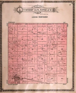
Old Vintage 1910 Plat Map ~ LEEDS Twp., BENSON Co., NORTH DAKOTA ~ Free S&H
C $46.650 bids4d 16h 8m

Old 1892 Chart - EARTH AROUND THE SUN ~ Authentic Atlas Map (11x14) -#P260
C $28.376% off

1887 Plat Map ~ KANSAS ~ ALLEN COUNTY, IOLA Twp. / HUMBOLT on Reverse #053
C $46.650 bids1d 15h 11m

Old 1897 Map ~ NEW HAMPSHIRE~ Authentic Atlas Map (LG15x22) -#060
C $42.416% off

Old 1878 Mitchell's School Atlas Map ~ WINDS & HURRICANES AROUND the WORLD
C $28.376% off

Old 1849 Authentic Mitchell Atlas Map ~ HEMISPHERES of the WORLD ~ Free S&H
C $28.376% off

1887 Map ~ NEWTON, KANSAS ~ Large City Map (32" x 36") Free S&H-#003
C $46.650 bids13h 40m

Rare 1852 Map ~ CENTRAL AMERICA - WEST INDIES, JAMAICA ~ (9.5x12) #P280
C $29.516% off

1863 Map of the WORLD on MERCATOR'S PROJECTION ~ Authentic Johnson Map #026
C $114.636% off

1892 Plat Map City of ROCKFORD, IL, Charles thru 11th St. / 14th thru State St.
C $88.840 bids3d 15h 56m

1863 Map ~ MAINE ~ Johnson Atlas Map (14x18)-#001
C $63.056% off

1903 Plat Map ~ NEWBURGH & BALMVILLE, ORANGE Co., NEW YORK (XL20x31)-#001
C $88.846% off

Old Authentic 1862 Johnson Atlas Map ~ ILLINOIS ~ (14x18) Free S&H
C $24.700 bids1d 13h 38m

1901 Plat Map ~ MASCOUTAH Twp., St. CLAIR Co., ILLINOIS (15x17)-#013
C $63.056% off

1831 Map ~ PACIFIC OCEAN - NEW HOLLAND - SANDWICH ISLANDS ~ (9x12) #P277
C $29.516% off

Nice 1888 R McNally Atlas Map~ OREGON ~ (LG14x20) Free S&H ~Inv#181
C $28.376% off

1875 Map LAKE SUPERIOR - UPPER MICHIGAN ~ Authentic Atlas Map (14x17)-#020
C $63.056% off

Old Antique 1864 Johnson Atlas Map ~ PENNSYLVANIA - NEW JERSEY ~ Free S&H
C $46.650 bids1d 12h 44m

1910 Plat Map OBERON, BRINSMADE, WARWICK, TOKIO Twp., BENSON Co., NORTH DAKOTA
C $63.056% off

Vintage 1899 Atlas Map ~ MARYLAND - DELAWARE Old Antique & Authentic ~ Free S&H
C $24.700 bids4d 13h 40m

1887 Map ~ EMPORIA, KANSAS ~ Large City Map (25" x 25") Free S&H-#006
C $46.650 bids13h 46m

Original 1929 Pictorial Map by L. Price ~ THE ATLANTIC OCEAN
C $28.376% off

Old 1892 UNITED STATES Map ~ Authentic Atlas Map (14x21) Free S&H #P208
C $28.376% off

Old Dated 1873 (Lg 17"x28") Topographical Map of the UNITED STATES & MEXICO
C $31.39

Old Original 1881 Plat Map ~ THE GREEN - WIER ST., TAUNTON, MA - HIGH ST.
C $63.050 bids3d 17h 3m

1901 Plat Map ~ ENGELMANN Twp., St. CLAIR Co., ILLINOIS (15x17)-#014
C $63.056% off

1865 War Map of RICHMOND VIRGINIA Johnson Atlas Map (18x27)-#015 (AS-IS))
C $28.376% off

1875 Map ~ POLITICAL, GEOLOGICAL & CLIMATE MAP of ILLINOIS (15x18)-#013
C $28.376% off

1887 Map ~ FORT SCOTT, KANSAS ~ Large City Map (21" x 24") Free S&H-#021
C $46.651 bid13h 56m

1875 Map ~ EASTERN & WESTERN HEMISPHERES of the WORLD - (XL17x27)-#033
C $63.056% off
About us
Welcome to my eBay Store. Please add me to your list of favorite sellers and visit often. Thank you for your business.
Store policies
Shipping
Seller feedback (8,813)
4***a (1414)- Feedback left by buyer.
Past month
Verified purchase
Good description, good price, fast shipping, good communication, great seller. Thank you
t***m (27)- Feedback left by buyer.
Past 6 months
Verified purchase
Item was as pictured and described. Packaged well. Shipped reasonably fast enough. Was originally shipped the wrong thing but the seller made it right. I definitely recommend this seller. A+++
k***3 (4054)- Feedback left by buyer.
Past 6 months
Verified purchase
Quick Shipping-Great Communication-Item arrived as described and well packaged-Very Pleased with seller-Recommended-A+++
k***3 (4054)- Feedback left by buyer.
Past 6 months
Verified purchase
Quick Shipping-Great Communication-Item arrived as described and well packaged-Very Pleased with seller-Recommended-A+++
e***i (97)- Feedback left by buyer.
Past 6 months
Verified purchase
Another great order from this seller. Super fast shipping and shipping packaging materials ensure the item arrived without damage. Item exactly as described and as in photos. Will continue to do business with this A+++++++ seller and purveyor of maps!
a***o (38)- Feedback left by buyer.
Past 6 months
Verified purchase
Accurately described, well packaged, really nice vintage map. I'd buy from this vendor again. My only feedback for the vendor -- it is cut out of an atlas (standard for this kind of map) and it came with a BEAUTIFUL map of Sacramento printed on the back; I didn't see any indication of the back details, but I'm treating that as a nice bonus instead of an issue.